


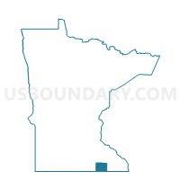
Lyle Twp. Voting District, Mower County, Minnesota
About
Outline

Summary
| Unique Area Identifier | 603247 |
| Name | Lyle Twp. Voting District |
| County | Mower County |
| State | Minnesota |
| Area (square miles) | 35.46 |
| Land Area (square miles) | 35.46 |
| Water Area (square miles) | 0.00 |
| % of Land Area | 100.00 |
| % of Water Area | 0.00 |
| Latitude of the Internal Point | 43.54416940 |
| Longtitude of the Internal Point | -92.99042900 |
Maps


Graphs
Select a template below for downloading or customizing gragh for Lyle Twp. Voting District, Mower County, Minnesota


Neighbors
Neighoring Voting District (by Name) Neighboring Voting District on the Map
- Austin Twp. Voting District, Mower County, MN
- DEER CREEK TWP Voting District, Worth County, IA
- London Twp. Voting District, Freeborn County, MN
- Lyle Voting District, Mower County, MN
- Nevada Twp. Voting District, Mower County, MN
- Oakland Twp. Voting District, Freeborn County, MN
- OTRANTO TWP Voting District, Mitchell County, IA
- Windom Twp. Voting District, Mower County, MN
Top 10 Neighboring County Subdivision (by Population) Neighboring County Subdivision on the Map
- Austin township, Mower County, MN (1,004)
- Windom township, Mower County, MN (606)
- Lyle city, Mower County, MN (551)
- Oakland township, Freeborn County, MN (396)
- Lyle township, Mower County, MN (356)
- Nevada township, Mower County, MN (338)
- Otranto township, Mitchell County, IA (338)
- London township, Freeborn County, MN (315)
- Deer Creek township, Worth County, IA (180)
Top 10 Neighboring Place (by Population) Neighboring Place on the Map
Top 10 Neighboring Unified School District (by Population) Neighboring Unified School District on the Map
- Austin Public School District, MN (28,150)
- St. Ansgar Community School District, IA (3,987)
- Southland Public School District, MN (3,562)
- Glenville-Emmons School District, MN (2,587)
- Lyle Public School District, MN (1,144)
Top 10 Neighboring State Legislative District Lower Chamber (by Population) Neighboring State Legislative District Lower Chamber on the Map
- State House District 27B, MN (37,406)
- State House District 27A, MN (35,241)
- State House District 14, IA (28,299)
- State House District 11, IA (27,572)
Top 10 Neighboring State Legislative District Upper Chamber (by Population) Neighboring State Legislative District Upper Chamber on the Map
- State Senate District 27, MN (72,647)
- State Senate District 7, IA (56,350)
- State Senate District 6, IA (55,559)
Top 10 Neighboring 111th Congressional District (by Population) Neighboring 111th Congressional District on the Map
Top 10 Neighboring Census Tract (by Population) Neighboring Census Tract on the Map
- Census Tract 13, Mower County, MN (4,577)
- Census Tract 10, Mower County, MN (3,615)
- Census Tract 5602, Mitchell County, IA (3,557)
- Census Tract 6901, Worth County, IA (2,442)
- Census Tract 1810, Freeborn County, MN (2,362)